COCEDORES
 This creek belongs to the coast of Almeria and Aguilas. By their morphology often target families with children in summer.
 |
| Edu Soto |
This creek belongs to the coast of Almeria and Aguilas. By their morphology often target families with children in summer. |
| Edu Soto |

 Near the end of the ride we hit the Plaza de Cristo Rey, it's decorated with tiles, the Tour finishes in the Rambla del Cañete, we pass the Green Casica Area, which is called as urbanization and the Beach Casica Verde.
 From the Development of the Casica Verde, the ground begins to have slight ups and downs along the various coves sandy or gravel. At halfway we find Matelentisco Beach, where you can observe a natural barrier that makes the shape of a pool.
 Following the coastline, we passed the beach area Matelentisco the Cueva de la Paloma, from now until the end of the tour, we can see the plates of rock loosened by the water over the years and the many waves. Before coming to the beach Calarreona, we find the Cocedores Beach, where once it was used by the natural barrier of straw cooker, and from a hill dominated by a machine gun in a bunker that makes us remember times less peaceful than today.
 Its works completed in 1884 and from the moment trading began Aguilas resurgence. Minerals were shipped from Almagrera Sierra and Sierra Almenara; esparto and minerals from Granada, Murcia, Albacete, Almeria and Jaen.
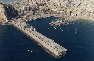
 The fishing port located along the commercial port, has the largest fishing fleet in the Region of Murcia. Located on the Bay as Levante Playa de Levante and Playa de las Delicias, from the Castle of San Juan de las Aguilas you will see some great views.